

Map Engravers
It has been interesting to discover that three generations of one Barcham family were map and chart engravers for the Ordnance Survey.
Ethel Fanny Barcham, born 16 December 1895 in Stepney, was the sixth child of Martha (née Smith) and William Edwards Barcham. In 1892 Ethel married Arthur Rowley Johnson, born 1865, in Newington, Surrey, who was the youngest child of Martha and Thomas Henry Johnson. The map engraving dynasty are enumerated in censuses from 1851 to 1901. Thomas Henry Johnson (b. 1823, at Brighton, son of a farmer, d. 1883) was a geographical draftsman; engraver, ordnance officer [at Southampton in 1861]; map draftsman; and map engraver [1881]. The fact that he was in Southampton provides a clue that he worked for the Ordnance Survey. Henry had three sons: Henry George (b.1851 at Pimlico, London) was an engraver [1871], map and plan engraver [1881], and geographical imprinter [1891] in London, then owned a tobacconists shop in Hornsey [1901]; Alfred (b.1859 at Hamble, Southampton) was a map engraver [1881] and an Admiralty chart engraver [1901] in London; Arthur (b. 1865 in Newington,Surrey) was a map engraver [1891] and map and chart engraver [1901], then married and living at 8 Langdons Road, Wood Green, Tottenham. In the next generation, Henry’s eldest son Henry (b. 1880 at Walthamstow, London) was a chart engraver [1901] then living with his parents at 169 Turnpike Lane, Hornsey. We do not know which maps that the Johnson family worked on. Engravers were specialised: some did the plans, others added lettering or the symbols such as trees, churches, etc.
In 1881 Martha, Thomas and their sons lived at 187 Dalston Lane, Hackney. The large scale Ordnance Survey map (London sheet 7.08) shows that this was a large semi-
Henry Johnson was buried in Abney Park Cemetery. The Johnsons were a close-
The Ordnance Survey map offices were at the Tower of London and in Southampton (where it is still today). The first survey of England was made in the 1820s and 1830s, from which the original drawings were drafted. Colonel Colby was appointed by the Board of Ordnance to direct the survey of England and Wales.
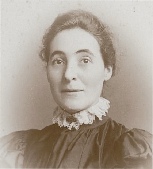
Ethel Fanny (née Barcham) Johnson
The work was done by a team of skilled engravers with specialists in hills, water, woods, lettering, etc. who worked on copper sheets. Proof impressions were printed and sent out for checking , then corrections and revisions were made. The maps were printed on a press in the Tower. They were sold by James Gardner of 163 Regent Street, London. The process of electrotyping was introduced in 1847, enabling duplicate copper-
| Norfolk Barchams |
| London Barchams |
| Australia |
| New Zealand |
| Canada and US |
| Seafaring |
| Occupations |
| Military Service |
| Schools |
| Sports |
| Orphans |
| Cemeteries |
| Updates |
| Early Barchams |
| Download Trees |
| Connections |
| Family Photos |
| Memorabilia |
| Announcements |
| Obituaries |